1898 - 1921
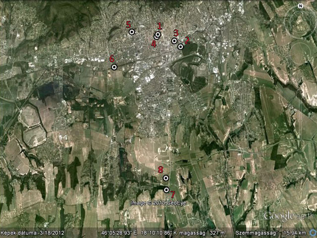
At first, meteorological measurements were performed in the center of Pécs from 1898 in the patio of the house in Apáca street 14. Surrounded by tall concrete walls, it was a typical "urban" station.
From September 1, 1916, measurements were moved to the local Intitution of Disinfection with an open area, providing better circumstances. Temperature was measured by the northern side of the building. In 1918, measurements were interrupted, because the country was occupied by Serbia. Until November 1921, data were refilled by the nearest synoptic station located in Szálka.
 1921 - 1957
Measuring was continued in November 22, 1921. This time, measurements were performed at the building in Rákóczi street 80, which became a university later. One year later, from June 26, 1922, because of the shortage of the staff, the station was moved to Notre Dame Nunnery in Apáca street. After two years, the station was brought back to the university in October 22, 1924, and was used for another 20 years. Measuring of the sunshine duration also began here.

As the war went on, measuring became harder, and from July 1943 until November 1944, its place alternated between the university and the station of Pius Institute (founded in 1931). From December 1, 1944, observations were discontinued at both places. Until april 30, 1945, data of the station is Szekszárd were used. From May 1, 1946, the station of the university in Rákóczi street is used, but only for a couple of months, as from February 19, 1946, obervations were made at the airport of Mecsekalja until March 31, 1957. From the beginning, all the stations were located within a one-kilometer radius.
 1956 - 2004
In July 7, 1956, there was a big change in the measurements, because the new station was located 10 km south of the town, in the airport of Pécs-Pogány. Despite the fact that it was 200 meters above sea level (50 meters higher than the urban stations), the location of the instuments were ideal.
Until March 3, 1969, the airport gave home to the station, but until 24 March, 1998, measurements were continued a couple of hundred meters farther, then it was moved back to the airport.
| Number | Name of the station | Latitude | Longitude | Beginning of the period | End of the period |
|---|---|---|---|---|---|
| 1 | Pécs; Apáca street 14. | 46°04'37"N | 18°13'29"E | 06.01.1898. | 08.31.1916. |
| 2 | Pécs; Institution of Disinfection | 46°04'16"N | 18°14'30"E | 09.01.1916. | 11.12.1921. |
| 3 | Pécs; Erzsébet University | 46°04'26"N | 18°14'13"E | 11.22.1921. | 02.18.1946. |
| 4 | Pécs; Notre Dame Nunnery | 46°04'33"N | 18°13'23"E | 06.26.1922. | 10.21.1924. |
| 5 | Pécs; Academy of Pedagogy | 46°04'40"N | 18°12'20"E | 11.26.1931. | 02.28.1963. |
| 6 | Pécs; Airport of Mecsekalja | 46°03'37"N | 18°11'35"E | 02.19.1946. | 03.31.1957. |
| 7 | Pécs Meteorological Station (airport) | 46°00'00"N | 18°14'00"E | 06.02.1956. 03.24.1998. |
03.03.1969. as of today |
| 8 | Pécs-Pogány; Airport (outbuilding) | 46°00'21"N | 18°13'58"E | 03.03.1969. | 03.24.1998. |