The Hungarian Meteorological Service (OMSZ) has provided its medium-range weather forecasts made on ECMWF’s model forecasts since 1995. Hungary, as a co-operative state of ECMWF widely uses ECMWF’s archive and softwares. OMSZ has made intensive developments based on ECMWF’s models. OMSZ has been taking part in ECMWF’s Educational Programme and some colleagues has been involved in research and developments done at ECMWF since 2004. The medium-range forecasts of OMSZ’s public web based on ECMWF’s probabilistic forecasts. The following summary contains these main points:
- Relationship between Hungary and ECMWF
- Fundaments of probabilistic weather forecasting
- Operational numerical forecasts at ECMWF
- Research and development based on ECMWF’s model products at OMSZ
- Use of the ECMWF's model products at OMSZ
Relationship between Hungary and ECMWF
1 July 1994 Hungary became a co-operating state of the European Centre for Medium Range Weather Forecasts (ECMWF) as first country from Central Eastern European region. The basic aim of the forecasting centre is to provide medium range numerical weather forecasts of high quality. ECMWF is operationally running global deterministic and ensemble models covering the whole Earth (Fig. 1). You can find comprehensive information about ECMWF and its activity on its web site. The Hungarian Meteorological Service has access to the whole range of ECMWF's products, as Hungary is co-operating state of this organization. Comprehensive guide can be found too on ECMWF web.

Figure 1.
Geopotential and temperature 15 h forecast (valid for 15 UTC 6 June 2012) on 500 hPa pressure level
as it is displayed in HAWK-3 visualization system of OMSZ
After ratifying the amended convention of ECMWF since June 2010 co-operating state can apply to become full member of the organization. Till the beginning of 2021 four countries – Island, Slovenia, Serbia, Croatia and Estonia – became the full member of ECMWF. Hungary could start the preparatory steps after resolution 1492/2011 (XII. 27.) of the government was accepted.
Fundaments of the probabilistic weather forecasting
Weather forecasting could not be perfect due to for reasons. First of all full initial state of the atmosphere could not be known. Due to uncertainties coming from the chaotic behaviour of the atmosphere some weather situations can be less predictable. In any numerical weather prediction models model could not be perfect and some approaches are needed during solving the mathematical equations.
During forecasts made by any numerical models success depends on several reasons. In numerical weather prediction models atmospheric processes can be formalised by laws of the physics, like equations of mass and energy conservations. The complex physical interactions could not be fully correctly described and some approximations are applied. To solve the equations with numerical weather prediction models, it is crucial to describe the initial conditions with the highest possible accuracy. Usage of the huge amounts of the high quality – surface, upper air, satellite etc – observations is essential. Observations always have smaller or larger errors, so monitoring of their reliability is also very important. Numerical weather prediction models use regular horizontal and vertical grid, but observations are located irregularly in space and occasionally in time, too. Interpolation is needed between the two networks. The numerical forecast is calculated by integrations from the initial state. Final products provided for general public are generated by postprocessing the model results.
Considering the above mentioned problems ensemble modelling was developed to provide probabilistic forecasts about three decades ago. The ensemble method takes into account uncertainties in observations, applied numerical models and physical parameterizations. At the first step of the ensemble forecasting perturbed initial states are generated, then numerical model is integrated from each initial states while perturbations are introduced also for some parameters during integration of the equation system. By using the full set of the ensemble forecasts it is possible to estimate the uncertainty of any forecasted weather elements. It is advised to study comprehensively the ensemble mean, full ensemble spread and probability distribution. Ensemble forecasts can be successfully used to predict extreme weather situations, too.
Operational numerical weather forecasts at ECMWF
- High resolution forecast
At ECMWF in Reading (United Kingdom) a 10-day high resolution (deterministic) forecast based on 0 and 12 UTC analysis is operationally launched by applying IFS (Integrated Forecasting System) model twice a day. The model is taking into account several physical interactions like between ocean and atmosphere, soil wetness and atmosphere and snow surface and atmosphere. The model contains 136 layers between surface and 0.1 hPa pressure level in vertical, and its horizontal resolution is about 9 km (Fig. 2).
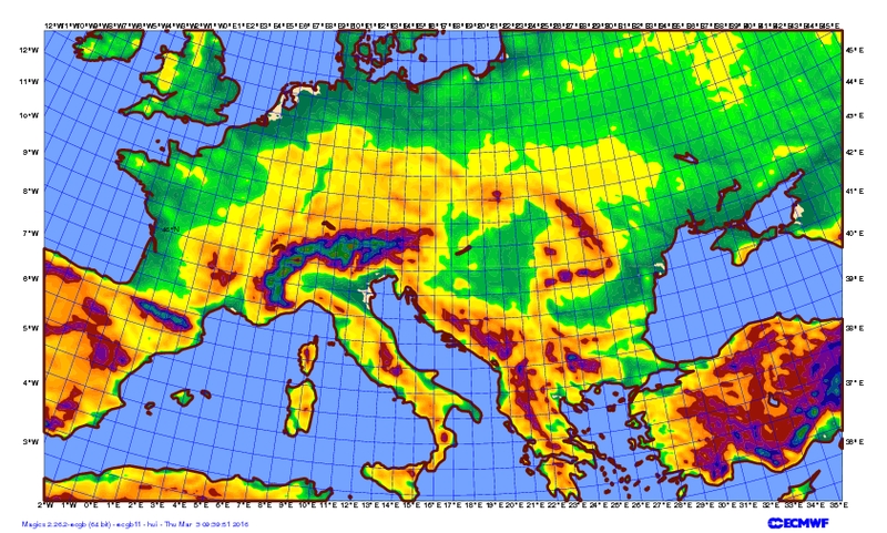
Figure 2.
Model orography of the high resolution model
- Ensemble forecasts
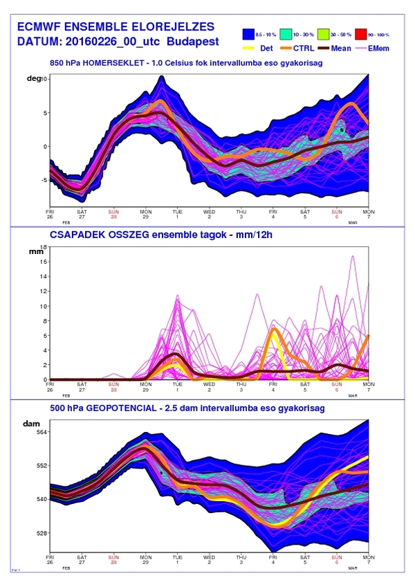
Forecast errors are significantly growing in time due to the chaotic behaviour of the atmosphere and the insufficient initial observed data. Taking into account above-mentioned effects makes probability forecasts, so called ensemble forecasts. Using ensemble-forecasting technique smaller perturbations are given on the initial field of the model above sensitive areas depending on weather situation. In this way the model is starting from initial conditions more or less different from original analysis. Besides that, uncertainties from approximation of the physical processes are taken into account during the model integration, too. After several days the differences may become higher even if the initial differences were small (Fig. 3).
 |
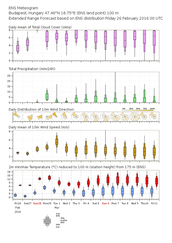 |
Figure 3.
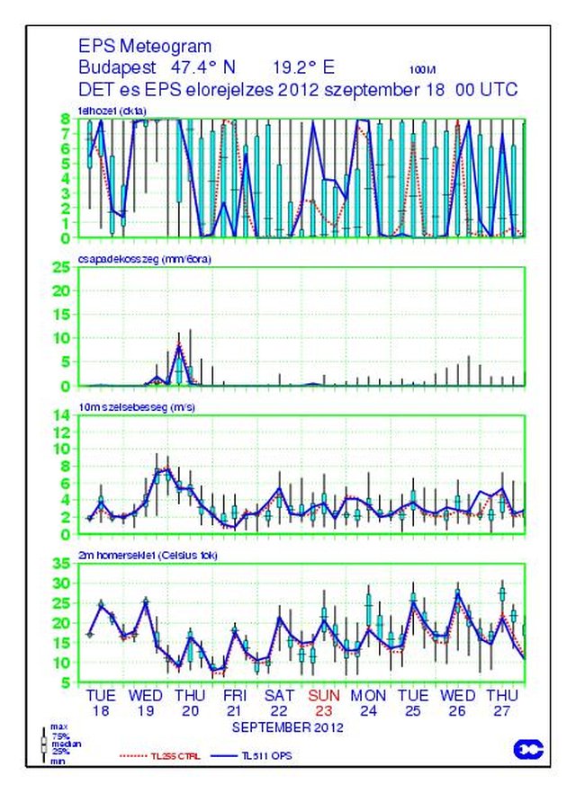
Ensemble plume and meteogram forecast based on 0 UTC 26 February 2016
In the end of 1992 the first 10-day probability forecasts were made by using ensemble method. Its current version has 51 ensemble members. The structure of the ensemble forecast is very similar to the high resolution one, only the spatial resolution of the model is lower in order to decrease the long computing time. Horizontal resolution is recently about 18 km (Fig. 4). Number of the vertical layers is 136. At 0 and 12 UTC model runs up to 15 day and 6 and 18 UTC it runs up to 7 days.
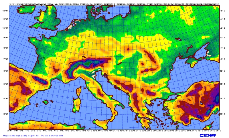
Figure 4.
Model orography of the ensemble model
Developing forecasts of the extreme and severe events is one of the main aims of the long-range (2021-2030) Strategic Plan of ECMWF. Due to the fact that forecast of severe events is an important task of OMSZ as well, strong co-operation was established and several investigations have been made in this respect (Fig. 5).
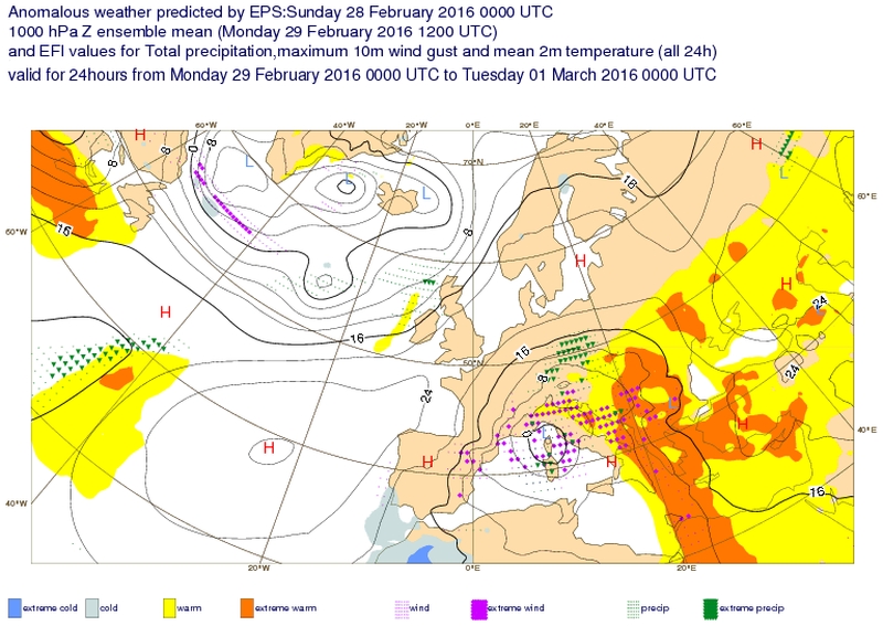
Figure 5.
EFI chart valid for 6 May 2015, forecast based on 0 UTC 3 May 2015
- Monthly and seasonal forecasts
In last decade the results of the scientific researchers could allow us to investigate influence of sea surface temperature anomalies – i.e. differences from the climatological average - on atmosphere. Lower boundary conditions as sea surface temperature, soil wetness and snow surface affect the state of the atmosphere. The El Nino phenomenon is significantly influencing the general circulation of the atmosphere. Using coupled ocean-atmosphere circulation models may extend the forecast range.
Predictability can be improved by two factors:
- The development of measuring technique can provide information on temperature in 500 m layer of the upper ocean. Satellite measurements give huge amount of information about wind speed, temperature and humidity.
- Numerical models drawing interactions between the ocean and the atmosphere were developed significantly the last several years.
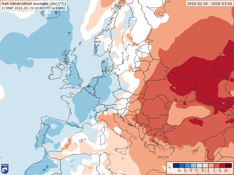
ECMWF started experimental seasonal forecast project in 1995. The first quasi-operational seasonal forecast was made in June 1998. Both monthly and seasonal forecasting ensemble models contain 51 members and its spatial resolution is 50 and 80 km respectively. Nowadays monthly forecast is made twice a week, each Monday and Thursday and seasonal forecast (Fig. 6) is made once a month, 8th day of each month.
 |
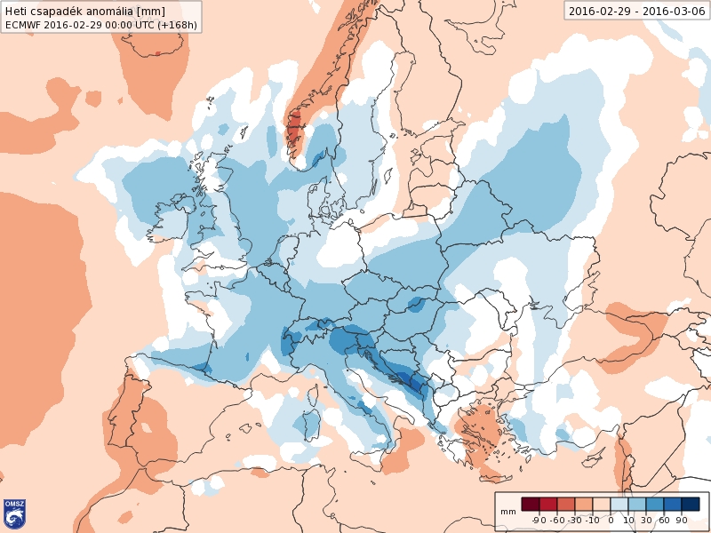 |
Figure 6.
Weekly forecasts of temperature and precipitation anomalies between 29 February 2016 and 6 March 2016
- Reanalysises at ECMWF
Knowledge of the current state of the atmosphere is indispensable at gridded space where numerical weather prediction model works. This state is given by mathematical methods, namely data assimilation based on current observations (surface, upper air, satellite, etc.) and ultra short-range forecast of former model run, valid for the same time. Nowadays weather forecasting systems are very well developed, so due to this fact observations are much more accurately used at analysis then it happened a few decades ago. During production of the so called reanalysis datasets, state of the atmosphere can be described much more preciously by applying state of the art methodology on a few decades long observation datasets than it happened when the original analysis was made. In addition applying unified data assimilation method on the whole time range will cause consistent dataset avoiding the inhomogenitiies coming from model developments. So reanalyses are much more suitable for studying the long range climate change than operational analyses. Even reanalysis dataset can represent quite well the climate, there are some uncertainty due to errors in observations and modelling.
First reanalysis, ERA-15 covering 1979-1993 was made in middle of 1990-s. In the beginning of the 2000-s ERA-40, covering 1958-2002 was made. In the middle of 2000-s ERA Interim project started, it provides reliable reanalysis from January 1979 and the dataset was continuously extended until 2018. It was based on IFS version which was operational in 2006. A new reanalysis project, ERA-CLIM was established that was funded by the European Commission under the 7th Framework Programme and involved ECMWF and several other organizations. The result of this project was a complete ERA-20C reanalysis covering the whole 20th century. During last couple of years state of the art reanalysis, ERA5 was developed. This new reanalysis replaces the highly successful ERA-Interim. It spans the period from 1979 to the present. ERA5 is based on 4D-Var data assimilation using IFS model version which was operational at ECMWF in 2016. ERA5 thus benefits from a decade of developments in model physics, core dynamics and data assimilation relative to ERA-Interim. In addition to a significantly enhanced horizontal resolution (31 km grid spacing compared to 79 km for ERA-Interim), ERA5 has a number of innovative features including hourly outputs and an uncertainty estimate. The uncertainty information is obtained from a 10-member ensemble of data assimilations with 3-hourly outputs at half of the horizontal resolution (63 km grid spacing). Table I. contains main characteristics of the above mentioned reanalyses.
|
|
ERA-15 |
ERA-40 |
ERA-Interim |
ERA-20C |
ERA5 |
|
Time range |
1979–1993 |
1957–2002 |
1979–2018 |
1900–2010 |
1950– |
|
Horizontal resolution |
125 km |
125 km |
75 km |
125 km |
31 km |
|
Vertical resolution |
31 levels |
60 levels |
60 levels |
91 levels |
137 levels |
|
Data assimilation |
optimális interpoláció + 1D-var |
3D-var FGAT |
4D-var |
4D-var |
4D-var |
Table I. Main characteristics of ECMWF reanalyses
Research and development based on ECMWF’s model products at OMSZ
In the Hungarian Meteorological Service ECMWF related activity devoted for the following main topics:
- Producing graphical products for HAWK-3 visualization, OMSZ external web portal and intraweb
- Verification of the deterministic and ensemble forecasts
- Clustering of ensemble forecasts focusing on Carpathian-basin
- Downscaling global forecasts and re-analyses by using fine resolution numerical models
- Ensemble calibration
- Producing ensemble vertical profile
- Study of the ensemble dispersion models
- Study of the cold drops by using ECMWF ERA Interim reanalysis database.
- Producing graphical products for HAWK-3 visualization, OMSZ external and internal web portals
Final outputs of the numerical weather prediction models are available in binary format, so called GRIB files. In HAWK-3 visualization developed by OMSZ 2D horizontal and vertical cross sections can be displayed. In addition to own visualization method of the HAWK-3 it is possible to display external image files, too. In OMSZ wide-range of the graphical products, like ensemble meteograms, plumes, histograms, probability maps made by using MAGICS software developed by ECMWF. Graphical products partly help the forecasters’ work and partly available on external web.
- Verification of the deterministic and ensemble forecasts
Verification of the forecasts is essential for people (forecasters, end users, etc.) applying the model and model developers, too. Verification of the deterministic forecasts is an easier task than verification of the ensemble models. ECMWF provided a guidance for verification of the ensemble forecasts (Nurmi, 2003). ECMWF has regularly collected the verification results made by member states and co-operating states. This summary is available on ECMWF’s web. Verification is needed to be done at national level, because NMS-s have the best available observed datasets.
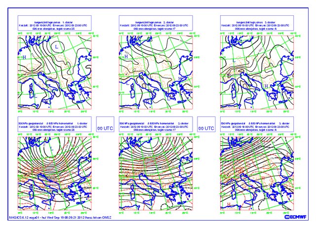
- Clustering of ensemble forecasts focusing on Carpathian Basin
51 member ensemble forecasts can be used and displayed by several techniques. Besides ensemble meteograms and plumes so called spaghetti and stamp diagrams can be used well. Applying stamp diagram each weather patterns connected to the relevant ensemble members can be studied. By clustering the full set of the ensemble a few (2-6) main weather patterns are determined. Studying the clustering regimes potential reasons of the uncertainties can be determined and understood.
- Downscaling ensemble forecasts by using fine resolution numerical models
Downscaling of the global ensemble systems can be made by several methods. Downscaling of the full (51 members) could not be achieved by and national meteorological services, including the largest ones, because it would need a huge amount of central processing unit (CPU) time. A limited area model, ALADIN/HU used in OMSZ was launching from the initial state of the 10 fixed cluster representative members. Comparison of the global and limited area models was investigated in case studies connected to severe weather situations.
In operational practice ECMWF’s forecasts provides large-scale information for limited area models. ECMWF’s high resolution model supplies lateral boundary conditions for 8 km resolution ALADIN/HU and 2.5 km resolution AROME/HU forecasts. AROME-EPS forecasts are downscaling 11 members of ECMWF’s ensemble forecasts at 2.5 km-s resolution.
In climate research experiments, the lateral boundary conditions are provided from reanalyses for validation of regional climate models. At OMSZ REMO and ALADIN-Climate regional climate models are studied by using ERA40 and ERA-Interim reanalyses.
- Ensemble calibration
The numerical weather prediction models contain error as it was written in chapter “Fundaments of the probability weather forecasting”. Besides the above mentioned reasons current 18*18 km-s horizontal resolution of the ensemble model could not subscribe the subgrid orography well. These problems can be partly solved by so called ensemble calibration. In OMSZ so called calibration based on comparisons of the distributions was applied. Distribution of the model climate has been made from 20 years reforecast ensemble datasets twice a week since 2015. Each member of the current ensemble forecasts is compared to the distribution of the model climate. Frequency of each forecasted value was determined in model climate. Then calibrated values were determined by applying these frequencies in observed climate.
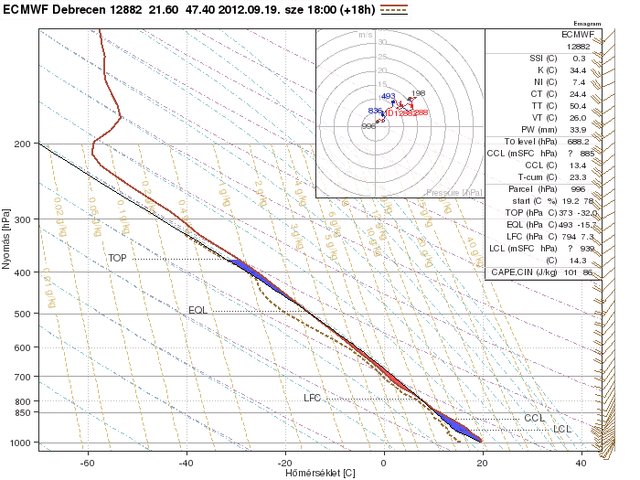
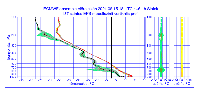
- Producing ensemble vertical profile
To make successful weather forecast it is necessary to know well the 3-dimensional state of the atmosphere. Ensemble meteograms, plumes and maps on isobaric levels are used for this purpose. It’s important to note the complex application of these above-mentioned methods could not always described very preciously the changes of the atmosphere and uncertainties of the forecasted weather. A completely newly developed approach, the so-called ensemble vertical profile method can provide useful additional information. Fine vertical structure of the atmosphere can be studied by applying ensemble vertical profile in 3-hourly resolution up to 6 days.
- Study of the ensemble dispersion models
Forecast of the natural (volcanic ash) and anthropogenic (radioactive gas and aerosol) pollutants is an important task of the national meteorological services. Input data of the dispersion and trajectory models is provided by 3-D outputs of the numerical weather prediction models. Dispersion and trajectory models are generally driven by deterministic NWP models. In 2011 and 2012 at OMSZ a pioneering activity was done to develop a system when probabilistic dispersion and trajectory calculation are done. Dispersion and trajectory models start from representative members of the ensemble clusters. This method is quite fast and it does not require too much CPUs.
- Study of the cold drops by using ECMWF ERA Interim reanalysis database
Cold drops or cold vortexes analysed around 500 hPa in the middle troposphere often cause severe weather, heavy snow showers in winters and heavy thunderstorms, occasionally tornadoes in summers. Forecast of these events are quite often not so easy. During in our study made between 2011 and 2014 statistical investigation was made on dataset collected from 150 cases from the last 15 years. Predictability of the cold droops was investigated based on ERA-Interim, deterministic and ensemble models. A new type plume diagram was also developed for characterizing cold drops well.
Use of the ECMWF's model products at OMSZ
At the Hungarian Meteorological Service ECMWF model forecasts have been operationally used since 1995. ECMWF central data archive and wide range of developed ECMWF softwares are intensively used by the experts of OMSZ, as we have free access to them based on the co-operating agreement between Hungary and ECMWF. Our researchers and forecasters are regularly taking part in the educational and training programme of ECMWF, since 2002 we have had opportunity to take part in the work of ECMWF in Reading. OpenIFS model, which is a version of IFS model for research and education has been used for teaching students since 2013. Medium range forecasts displayed on the web site of OMSZ are based on ECMWF model forecasts. Our several further services are also based on ECMWF forecasts. A summary about the validation of forecasts is shown on the verification portal of OMSZ. Annual reports are available on ECMWF’s web. Easily comparable verification is made by common methodology by each national meteorological service of the ECMWF states and member states.
Last two decades applications were developed in the division devoting its activity for developing numerical models and methods for supporting weather forecasts. Among other products:
 |
|
 |
|
 |
|
 |
|
 |
|
Further information and documentation about applications of the ECMWF’s model in Hungary: ecmwf_documentation_en.pdf
Links:
- www.ecmwf.int/en/forecasts/documentation-and-support
- www.ecmwf.int/en/research/modelling-and-prediction/forecast-evaluation
- www.ecmwf.int/en/research
- www.ecmwf.int/en/research/climate-reanalysis
- www.ecmwf.int/en/learning/training
Updated:11 May 2021