Results and CarpatClim data
Newly derived daily Penman-Monteith reference evapotranspiration values based on CarpatClim dataset
Background and details of the project
The Carpathian Mountains define the climate of the Carpathian basin, and also the region surrounding it. The mountains and the neighbouring basins are a geographic connection between the Northern and Southern European ecosystems, they grant habitat to numerous species of plants and animals. The climate is formed by oceanic, continental and mediterranean effects, as well as altitude factors. More than 20 million are living in the region that includes parts of Austria, the Czech Republic, Slovakia, Ukraine, Poland, Hungary, Romania, Croatia and Serbia. The climate change is expected to cause remarkable consequences to both the natural ecosystems and human activity. Therefore the unified description of this region that has various characteristics of terrain, natural conditions, cultural features and political borders is particularly actual.
The aim of this tender is the spatial and temporal examination the climate of the Carpathian Region (Fig. 1) using harmonized data and standard methodology. The leader of the winning consortium is the Hungarian Meteorological Service. Carrying out the project is based on the data homogenization method MASH (Multiple Analysis of Series for Homogenization, Szentimrey) and the interpolating method MISH (Meteorological Interpolation based on Surface Homogenized Data Basis, Szentimrey, Bihari) that were developed at the Climate Department of the HMS. The mathematical processes of these internationally acclaimed automatic data processing methods play a key role in the implementation. At the end of the project the digital climate atlas of the region will be produced, that can be the basis of regional climate change studies and other climatological research. Results will be used by the JRC (Joint Research Center Institute for Environment and Sustainability) primarily for drought assessment in the frame of the EDO (European Drought Observatory).
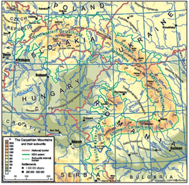 Figure 1: Carpathian Region (between 44° and 50° N and 17° and 27° E)
The aim of the tender:
- Producing the digital climate atlas of the Carpathian region
- Daily meteorological data in 0.1° resolution from 1961 to 2010
Participants
- Hungarian Meteorological Service, OMSZ, Hungary, consortium leader
- Slovak Hydrometeorological Service, SHMU, Slovakia
- Republic Hydrometeorological Service of Serbia, RHMSS, Serbia
- Czech Hydrometeorological Institute, CHMI, Czech Republic
- Institute of Meteorology and Water Management, IMGW, Poland
- Ukrainian Hydrometeorological Institute, UHMI, Ukraine
- Ministry of Environment National Research and Development Institute for Environmental Protection, DDNIRD, Romania
- Central Institute for Meteorology and Geodinamics, ZAMG, Austria
- Szent Istvan University, SZIE, Hungary
Subcontractor: Meteorological and Hydrological Service, DHMZ, Croatia
The contract signed: 20 December 2010
Total budget: 1 495 000 EUR
Duration: 24 months for preparing + 12 months to host the website
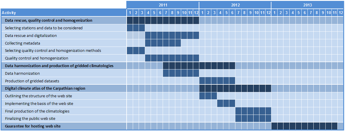
Modules:
Module 1
Data rescue, quality control, and data homogenization
leader: Slovak Hydrometeorological Service
1.1 Metadata and data rescue
leader: Slovak Hydrometeorological Service
1.2 Bilateral data exchange
leader: Szent István University
1.3 Quality control and data homogenization
leader: Hungarian Meteorological Service
Module 2
Climate data harmonization and production of gridded climatologies per country
leader: Hungarian Meteorological Service
Module 3
Digital climate atlas of the carpathian region
leader: Republic Hydrometeorological Service of Serbia
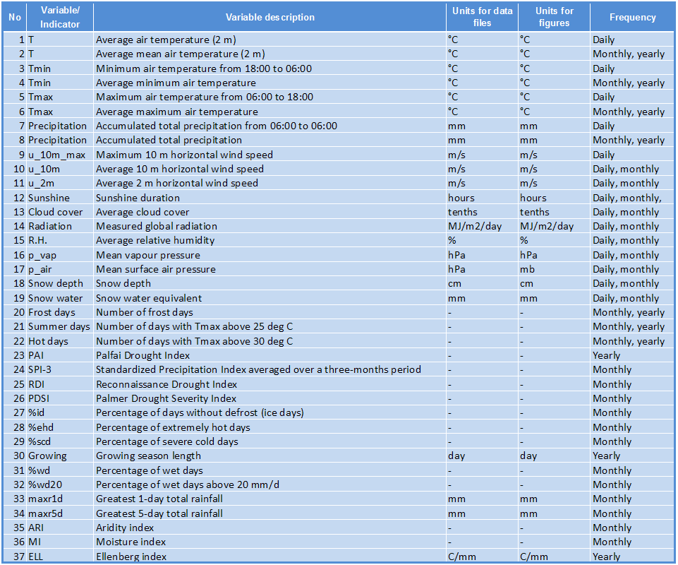
Climatic parameters to create:
Deadlines:
Events:
Consortium meetings
- 18-18 April 2011 Budapest
- 18-19 July 2011, Bratislava
- 28 October 2011, Budapest
- 31 January – 1 February 2012, Kraków
- 2-3 April 2012, Gödöllő
- 4-5 July 2012, Mahmudia
Homogenization training
- 6-7 December 2011 Budapest, OMSZ
Softwares:
- MASH (Multiple Analysis of Series for Homogenization, Szentimrey)
- MISH (Meteorological Interpolation based on Surface Homogenized Data Basis, Szentimrey, Bihari)
Contacts: bihari.z@met.hu, szentimrey.t@met.hu, lakatos.m@met.hu